Notifications
Clear all
Topic starter
28/07/2023 6:05 pm
Color representation
Red: data collected by a survey magnetometer, such as a MagArrow
Green: survey data we are interested in
Blue: base-station data
Magnetic field is a function of location (r) and time (t): B(r,t)
In general, we are only interested in magnetic field as a function of location: B(r).
Ideally, we set up one magnetometer at each location of interest and measure the magnetic field at different locations at the same time. This method removes the time dependence.
However, the method requires many magnetometers. The common practice is to move one magnetometer around. In this case, B(r,t) is collected since it takes time to move the magnetometer.
To remove the time dependence, a base-station is required. Assume the base-station reading at a fixed location R1 is B1(R1,t) = c1 + B1(t), where c1 is a constant, depending on R1. We hope to achieve the base-station correction B(r,t) - B1(R1,t) = B(r) – c1.
For a single base-station location, c1 can be ignored since it is a constant offset applied to the whole survey area. In another word, B(r) and B(r) – c1 generate the same survey color map.
For large scale surveys, it is impossible to have a single base-station location, since it is not economical and magnetic field time dependence is also regional.
Now we obtain base-station data sets at different locations: B1(R1,t), B2(R2,t), B3(R3,t)…
When the base-station correction is applied, Bi(r,t) - Bi(Ri,t) = Bi(r) – ci. In general, ci are different. Therefore, Bi(r,t) - Bi(Ri,t) can NOT be combined directly into a single data base unless constant offsets are applied to achieve Bi(r).
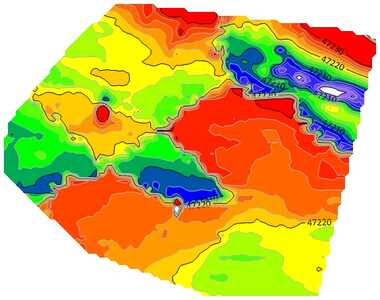
A typical combined 5-day survey without applying offsets is shown below.
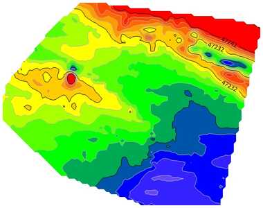
These constant offsets are hard to measure, unless multi base-stations are set up. However, they can be calculated based on the overlapping areas between two data sets since the readings in the overlapping areas must be the same, assuming the same AGL (above ground level). With this method, the new combined data is shown below.
Geometrics offers an auto survey combination program for MagArrow and MagEx customers.