Notifications
Clear all
Topic starter
21/08/2023 6:27 pm
This is most likely due to the fact that land surveys are typically much closer to the ground (therefore closer to targets). Two spatially separated magnetic anomalies can be resolved on the ground but not several meters above the ground, as shown in the simulation plot below. The simulation is for two targets, separated by 4m, located at z= -2m, y=3m, x= 0m and z=-2m, y=7m, x=0m. The total magnetic signal on the x=0 plane from the two targets are plotted in 2D as a function of y and z (with z=0 being on the ground).
For land magnetometer surveys, z = 0.5m or less. If we draw a line at z = 0.5m (survey line), it is clear that there will be 2 peaks in the sensor reading along y direction as long as the magnetometer has a high enough sample rate. Therefore, the two targets can be resolved.
For MagArrow surveys, if the above ground level (AGL) is >3m, the two targets cannot be resolved no matter how high the sample rate is.
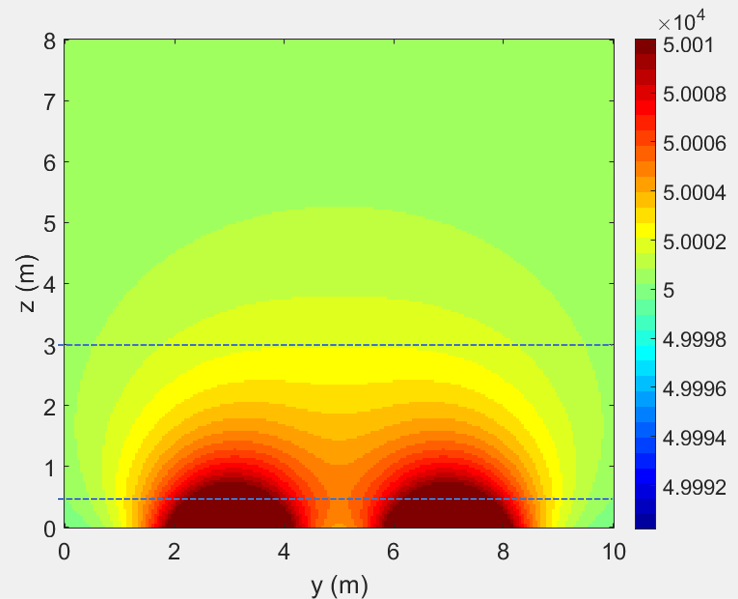
This simulation also indicates a rule of thumb about the linespacing in MagArrow surveys. The linespacing should be about 1-2 times the AGL. Less than the AGL will not produce any higher resolution map.
The simulation plot provides customers with a general idea of how fast the magnetic signal decays as a function of distance from the target. The signal falls as 1/R^3.