A recent demonstration of the Geometrics MagArrow Magnetometer mounted on Skyfront’s Perimeter X8 Hybrid Drone showed how seamlessly the two technologies work together to make UAV-magnetic surveying fast, easy, accurate, and safe. Both Geometrics and Skyfront are located in the San Francisco Bay Area, and the joint team performed the three-hour demonstration near Hollister, California, on what may have been the hottest day of the year. Despite the heat, an audience gathered to observe the ease at which the drone operator performed a very large magnetic survey that would have taken days to complete with a land magnetometer system and many flight blocks with a battery-powered UAV. The Perimeter X8 UAV stayed in the air with the MagArrow for over three hours without once requiring fuel or a battery replacement.
Geometrics has been on the forefront of magnetometer expertise for over 50 years. Founded in 1969 with the G-801 magnetometer, Geometrics has remained a world leader in magnetometer and geophysical technology. The newest addition to their lineup, the MagArrow, continues in that tradition.
The MagArrow Magnetometer consists of an aerodynamic, light-weight carbon fiber shell with internal electronics including MFAM magnetic sensors, GPS, WiFi, and IMU. The total package weighs in at 1 kg and has a 2.5-hour battery life. The MagArrow has two sensors, which are oriented orthogonally as to eliminate the dead zone, those areas near the earth’s poles and equator where traditional magnetometers lose signal.
The MFAM Magnetometer is what makes the MagArrow possible. Advances by Geometrics allow for a 10-fold reduction in size and power consumption without sacrificing performance. Each sensor is about 15cc in size and requires only 2W per sensor. The MFAM sensor is Geometrics’ most groundbreaking magnetometer ever, capable of highly precise magnetic measurements in an extremely lightweight and tiny package.
To learn more about the MagArrow, attend the upcoming MagArrow Magnetometer Webinar! Register to attend via the webinar banner.
Skyfront formed to solve the flight time limitation and unlock the true economic potential of unmanned aerial vehicles. After many iterations and tens of thousands of hours of research and development, the Perimeter drones were forged. The Perimeter 8X UAV holds the unofficial world record for endurance among commercially available multirotors. Off the shelf, it can fly for 5 hours and carry up to 4 kilograms of payload, all while maintaining the same simplicity and ease of use that made the multirotor popular in the first place.
With the Perimeter, missions that used to take days, multiple flight blocks, and many battery changes can now be performed in a single flight, enabling entire industries to scale their drone operations with ease. The Perimeter 8 has full propeller, motor, and ESC redundancy. This redundancy in addition to electronic fuel injection technology and a 5-minute battery backup reserve flight time ensures the safety of high-value payloads.
Combining the precision and reliability of the MagArrow with the easiest, safest, and longest endurance hybrid multirotor on the market, Geometrics and Skyfront have greatly enhanced the geophysical surveying market. Prior to the introduction of Skyfront’s hybrid gas-electric Perimeter series of drones, the limiting factor for UAV-mounted geophysical surveys was the aircraft’s battery life. For the typical drone, and without payload, battery life can be anywhere from 10 to 25 minutes. Introducing a payload, even something as lightweight as the 1 kg MagArrow, can significantly shorten flight time between battery changes. The battery required to fly from the survey site to the operator for a battery change is wasted in the context of a UAV-magnetic survey, and it is spent unproductively not collecting data. As labor expense makes up most of the cost of surveying, minimizing field time will have a positive effect on the bottom line.
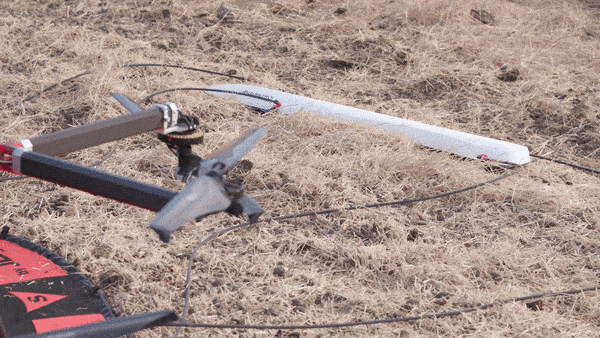
There are other benefits of using the Perimeter 8 drone with the MagArrow. One of the features many in the demonstration audience immediately remarked upon was the stability of the Perimeter X8 UAV with the MagArrow slung 3 meters below it, even when executing turns. It is important to prevent the magnetometer from swinging widely beneath the drone because the high-precision sub-meter UAV GPS is used in the data processing of the MagArrow.
The combination of a long-endurance drone like the Perimeter 8 and the light weight, low-power, and precise instrument like the MagArrow makes accessible those areas that are poorly served by traditional surveying methods. Traditionally, land surveys are performed either by tediously walking long lines or if the area is large enough and conditions are right, performing the survey using a small plane or helicopter. It can take days to weeks on foot to collect the data for a full survey depending on the goal. And while performing an airborne survey with a small plane or helicopter is fast, it is often not practical due to the expense or for safety reasons. Traditional airborne surveys also may not provide the detail one would need for many kinds of exploration projects. The new technology demonstrated by Geometrics and Skyfront eliminates these concerns and opens entire new areas to magnetic surveying. This technology is available now.
While the primary focus of the demonstration was to show how the Skyfront Perimeter 8 drone and the MagArrow worked together, the survey had a scientific purpose as well. During the test flight, it became obvious that something with a strong magnetic signature was affecting the data.
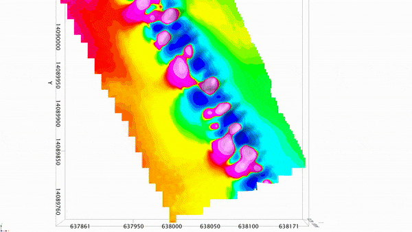
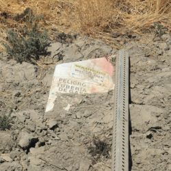
Preliminary data modeling in the field suggested a linear feature trending north-northwest. Visual inspection of the site did not indicate the presence of any feature, though at the end of the day a sharp-eyed individual spotted a sign buried in the mud warning of a buried gas pipeline. The MagArrow and Perimeter X8 UAV technology product demonstration incidentally ended up proving the validity of UAV-magnetics by finding and resolving the two gas pipelines that run underneath the test site. In many industries and with environments that change rapidly such as sand dunes, finding buried pipelines can be very difficult. The ultra-long-endurance magnetic surveying capabilities of the MagArrow paired with a Skyfront Perimeter UAV open up a whole new range of potential and use cases free from the limitation of conventional short flight time UAV platforms.
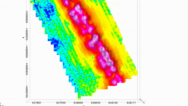
The final processed data shows the strong magnetic signature of a buried pipeline. Except for the fallen and buried sign, no other surface markers warned of utilities in the area. Data was processed using Oasis Montaj by Ron Bell of International Geophysical Services and by Kevin Hurley who works at Geometrics in the Magnetic Department
To learn more about the MagArrow, please click the button below to view our pre-recorded informational webinar.